Poland's network of marked hiking trails runs to roughly 77,000 kilometres — a figure compiled and maintained largely by the Polskie Towarzystwo Turystyczno-Krajoznawcze (PTTK), the country's main hiking organisation. That network spans everything from flat riverside footpaths in the lowlands to exposed ridge traverses above 2,000 metres in the High Tatras. The grading system that PTTK applies to those routes is practical rather than scientific — it describes what a walker will encounter, not their athletic capacity.
The three-tier grading system
PTTK does not use a numbered scale in the way that some alpine countries do. Instead, routes are classified into three broad bands that reflect a combination of distance, elevation gain, surface condition, and exposure to weather. The bands appear on trail signboards in Polish, but the logic behind them is consistent enough to learn quickly.
| Grade | Polish term | Typical terrain | Required experience |
|---|---|---|---|
| Easy | Łatwy | Compacted gravel, forest roads, gentle gradients below 15° | None — suitable for casual walkers and families |
| Moderate | Średnio trudny | Rocky paths, sustained climbs, occasional root sections | Basic fitness, appropriate footwear |
| Demanding | Trudny | Steep rock, fixed chains, exposed ridges, significant altitude | Mountain experience, physical conditioning, proper equipment |
These three grades are not always displayed on the trail markers themselves — the markers indicate direction and destination, not difficulty. Difficulty information appears on the large signboards at trailheads and in official PTTK guidebooks. The PTTK online map now includes difficulty filters that work across most marked routes.
What "easy" actually means on a Polish trail
Easy classification does not mean flat. In areas like the Bieszczady foothills or the Jura Krakowsko-Częstochowska, easy routes often climb 300–400 metres over the course of a day but do so gradually across good surfaces. The critical factor is predictability: an easy route should have no sections where a stumble leads to a serious fall, no exposed traverses, and no terrain that demands hands-on scrambling.
Seasonal variation affects what's considered easy. A compacted path through the Gorce in September is genuinely straightforward. The same path in March, under a consolidated snow layer with icy patches, is not. PTTK grades reflect summer conditions unless a route's signboard explicitly notes winter or year-round assessment.
Moderate routes: where most day hikes fall
The majority of popular single-day hikes in Poland's mountain ranges sit in the moderate band. Routes to summits like Babia Góra (1,725 m) via the northern approach, Śnieżka (1,603 m) from Karpacz, or Turbacz (1,310 m) in the Gorce Mountains all carry moderate classification. These are routes where the ascent is consistent and the surfaces variable — rock slabs interspersed with muddy stretches, tree roots, and wooden boardwalks over boggy sections.
The defining characteristic of moderate terrain in Polish mountains is the gradient. Sustained sections at 25–35° appear regularly, particularly on approaches to saddles. On these stretches, trekking poles reduce knee load on the descent substantially, which is why Polish hikers rarely set off on moderate routes without them.
Demanding routes and the role of fixed infrastructure
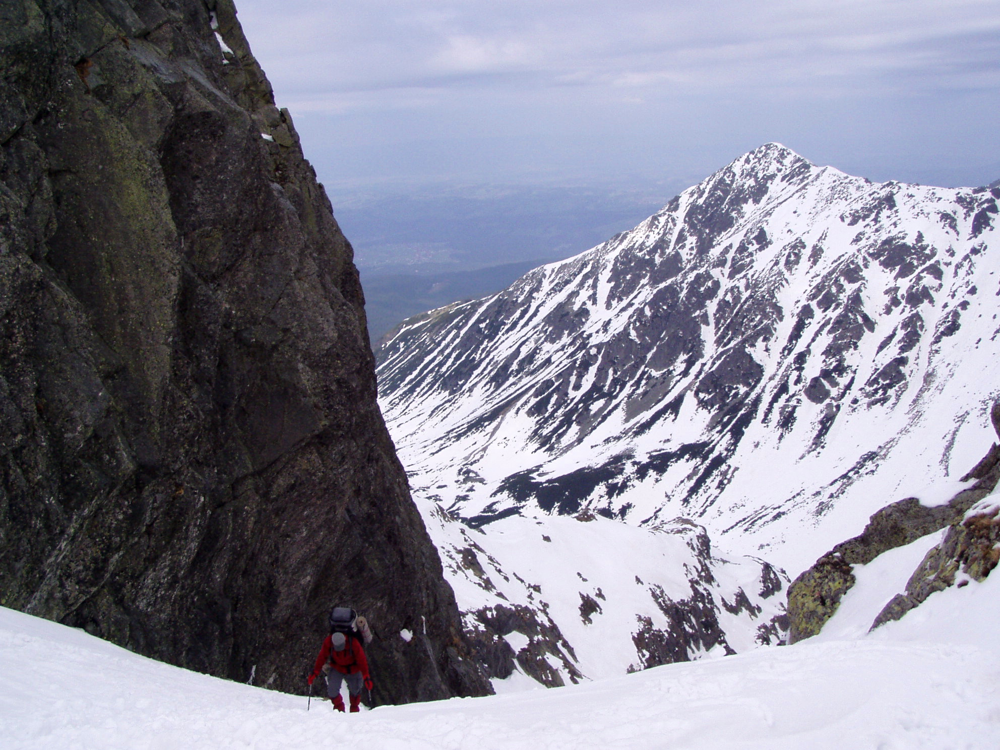
Demanding routes in Poland generally require metal chains, iron rungs, or wooden ladders at specific passages. The most well-known examples are concentrated in the High Tatras: the Orla Perć ridge traverse, rated the most technically challenging marked trail in Poland, uses 6 kilometres of fixed chains across genuinely exposed rock. Between 2015 and 2023, this section recorded multiple fatal incidents annually, according to Tatrzańskie Ochotnicze Pogotowie Ratunkowe (TOPR), the mountain rescue service for the Tatras.
Not all demanding routes involve exposed scrambling. Some receive the designation purely because of length — a 25-kilometre traverse with 1,800 metres of cumulative elevation gain will be classed demanding even if the individual sections are technically straightforward. This matters for planning: a difficult grade does not automatically mean technical skill is required, but it does mean that endurance and navigation ability matter more.
Regional differences worth knowing
Tatry (Tatras)
The most strictly managed mountain area in Poland, with seasonal closures on specific routes between December 1 and May 31. The Tatra National Park (TPN) publishes current trail status online and posts physical notices at park entrance points. Most routes above 1,500 metres fall into the moderate or demanding band.
Bieszczady
The southern Carpathians around Ustrzyki Górne are notable for open, treeless ridges called połoniny. Trails here are often easy to moderate in technical terms but require weather awareness — there is little shelter once above the treeline, and afternoon storms arrive quickly in summer.
Sudety
The Karkonosze range in the western Sudety records the highest annual visitor numbers of any Polish mountain area. Trails are well-maintained but experience heavy erosion. The ridge route between Szklarska Poręba and Karpacz is classified moderate, though sections near Śnieżne Kotły cirque require attention on wet rock.
Gorce and Beskid Sądecki
Lower in altitude than the Tatras, these ranges are forested to their summits and rarely present exposed terrain. Most routes here are easy to moderate, and the trail network is dense enough to construct loops of almost any length. Snow lingers on north-facing slopes until April, but crampons are rarely necessary.
How the PTTK system compares internationally
The SAC hiking scale used in Switzerland and Austria runs from T1 (path) to T6 (difficult alpine route), and the CAI scale in Italy uses a similar six-step progression. Poland's three-tier system is coarser — moderate covers a large range that would span T2 to T4 on the SAC scale — but it is legible and does not require prior knowledge of a specific grading framework to interpret.
Visitors from countries that use numbered difficulty grades sometimes find Polish signboards ambiguous. The practical solution is to check the PTTK map or guidebook for the specific elevation profile before setting off, rather than relying on the grade label alone.
Practical checklist before choosing a route
- Check the current trail status on the relevant national park or PTTK website.
- Note the elevation gain, not just the distance or grade.
- Verify whether the route requires specific footwear (crampons, via ferrata equipment).
- Check the forecast for the summit altitude, not the valley altitude.
- Plan your turnaround time — in summer, thunderstorms typically develop between 13:00 and 16:00.
Related reading: Waymarking systems on Polish hiking trails and Trekking equipment for Polish mountains.

